At the end of last year I wrote about fatal and serious cycle collisions within Hackney from 2009-2014. I have since acquired the same statistics for cycle collisions from 2004-2009 and so now have a complete breakdown of all 2095 collisions within Hackney involving people cycling that caused some kind of an injury for the ten year period up to the end of June 2014. Of these 2095 collisions 283 of them resulted in either serious or fatal injuries to the person cycling and I have mapped all of those collisions here:
Click here to view the map
Once again I've included the vehicles involved, age and sex of the person injured or killed and a brief description of the collision itself (again please note that these descriptions are lifted directly off the police report and not my own words). Here is a breakdown of the statistics:
Of those 283 collisions 271 resulted in serious injuries with 12 of them fatal. 65% of the collisions occurred on the main roads and 35% on B or unclassified roads.
Once again the A10 is the worst road in the borough by quite some distance for serious collisions with a staggering 28% of all cycling KSIs occurring on it. The A10 is a clear desire line for people cycling in the borough as it is a direct route though the heart of Hackney linking Stamford Hill, Stoke Newington, Dalston, Haggerston, Shoreditch and the City together within a few miles . I know I used this quote from the Hackney Council cycling plan in the last post but it is worth repeating here:
It is inevitable that cyclists will continue to use our busy high streets and strategic roads that carry high volumes of vehicular traffic because often they are the most direct and quickest routes.
I'll save my thoughts on the recently announced Cycle 'Superhighway' 1 for another time. The Shoreditch Triangle, Green Lanes and Mare Street in Hackney Central were also other collision blackspots
Statistics on the age and sex of those involved in the collisions is not that surprising: 42% were aged 18-29, 26% were aged 30-39 and 7% were children. 72% were male and 28% female. If you've spent any time on a street corner in Hackney watching the demographic of people cycling then it will not come as any great surprise that over 70% of people involved in these collisions were both male and under the age of 40.
As for the type of vehicles involved in the 'serious injury' collisions more than 70% involved people cycling being struck by a car with buses, lorries, vans and two cyclists colliding all accounting for about 5% each.
As for the twelve fatal collisions six of them, precisely 50%, occurred on the A10. Two were on the A106, one on the A102, one on the B113 Morning Lane (the point where it is a dual carriageway outside Tesco) and one occurred on Broadway Market. Five of the people killed were aged 18-29, six were in their thirties with the death in Broadway Market classed as "age unknown". Eight were male and four were female. As for vehicles involved again it is probably no great surprise that a Lorry was involved in just over half of the deaths, two involved a car and one each for bus, taxi and two cycles colliding. The fatal collision on Broadway Market was the fatal collision which involved two bicycles colliding; whilst the main roads in the borough are the most dangerous for people cycling, these tragic collisions can still occur in the most unlikely of circumstances.
Please take time to view the map and feel free to use it for your own research. In the eight months since this data was collated another two people cycling in Hackney have lost their lives and no doubt many more have suffered serious injuries. Lets hope that Hackney can learn from other countries and make improvements to the roads where these collisions occur.

Sunday 22 February 2015
Wednesday 11 February 2015
Olympic Park 2.5
This week marks two-and-a-half years since the closing ceremony of the Paralympic games and the Olympic Park being sealed off again to be transformed into legacy mode. My first post was written in the Summer of 2013 when the Northern section of the park reopened to the public. I followed that up when the Southern half opened up around nine months ago. Since then there have been a few small changes to the park and, as I continue to live close to it, I thought I may as well continue to keep you updated on some of these changes, in particular when it comes to accommodating cycling.
For us local residents living on the Hackney side of the Park a new pedestrian and cycle bridge recently opened into the park from Fish Island. Unfortunately as I pointed out on the day it opened it isn't great if you're intending to use it on a bike or with a pushchair (the two main ways I use the bridge) as you're directed to use the zig-zag path to the side of the steps, having to make six very sharp turns, something I found near impossible on my Dutch bike with its big fat front wheel

So like most people who cycled here I just used the desire line instead

But they've put a stop to that now, the bastards.

So if you do want to visit Fish Island with your family on a cargo bike then I'm afraid you'll just have to find another route. Fish Island is mainly known for its graffiti-ed warehouses which contain artists studios (worth a trip during the Hackney Wicked festival when they are opened up for the weekend). It's also home to some small independent businesses such as the cafe and roastery that I buy my coffee beans from, a smoked Salmon factory and the new home of Trumans Brewary. The empty warehouses won't be hosting pop up events for much longer though as there are many planning applications, which you can view here, here, here, here, here, here, here, here and here, to demolish a large chunk of Fish Island to make way for more characterless and unaffordable flats, most of which will be high up in the sky. Indeed some independent local businesses have already left so some of the unique features of the area are due to be lost forever
Fish island is not actually an island in the traditional sense of the word, it's just nicknamed that as it is hemmed in on all sides by either water, the A12 or victorian sewers. There is also only one road in and out which gives it the advantage it shares with other areas that have no through roads and that is a real lack of motor traffic. The bike and foot have a high mode share around here, perhaps beaten only by the learner drivers crawling around the streets at a very slow speed. I'm not sure how long it'll stay that way though as on a trip up to the top of the orbit I noticed the future map of the park on display showed the newly opened pedestrian bridge is to be replaced by a road bridge with a replacement pedestrian and cycle bridge built just a little further south instead. That seems to be confirmed by a similar layout on this map and also the new pedestrian bridge can be found here in this planning application. It'll be a real shame if another road is built into Fish Island which allows unlimited amounts of motor traffic to pass through. Currently everyone in Fish Island is either here for a reason or is lost; the South end of Hackney Wick was the same from 2007 until White Post Lane reopened last year. This area, along with Sweetwater on the other side of the river, will one day be home to thousands of people so it seems the London Legacy Development Corporation want motor vehicles to be able to speed through these areas unhindered, much like they've already allowed to happen within the Olympic Park itself.
Sweetwater is the name given to what is currently a vast empty area on the other side of the new bridge and where the worlds largest Mcdonalds traded for a few weeks in the Summer of 2012, along with the megastore. Sandwiched between the stadium and the river Lea it will one day have over 600 homes, a primary school, two nurseries, a library and a health centre. It was meant to stay empty until nearly 2030 but will now be completed within the next decade as development has been brought forward by a number of years in return for a reduction in the number of affordable housing, which sounds like a bad trade off to me. Back in the spring of last year the road leading into Sweetwater looked pretty much exactly the same as it did during the Olympics, when it was part of the ring road that ferried athletes to and from the Stadium:

And here is a picture I took in the Summer of last year, just as they had ripped everything up to start rebuilding the road again:

with the new final layout pictured below

I really don't understand why with all the space available here we have, yet again, ended up with the modern East London trend of building unnecessarily wide pavements whilst people cycling are expected to do so on the road directly in front of motor vehicles, presumably so as they can function as human speed bumps. You can pretty much guarantee the mums and kids heading to the nurseries or primary school here probably won't be cycling on the road. Below is an image of the new road compared with the Google maps Streetview image from the same location shortly before the Olympic games took place


I just think it is crazy to not build any provision for people cycling here if you're going to spend all that money ripping it up and replacing everything. This will not be a quiet road; it's named "loop Road" as, you've guessed it, this is the main road that loops around the southern half of the Olympic Park. It'll have flats on one side of it, a school and canal park on the other and it leads directly to the 54,000 capacity West Ham Stadium so the wide pavement should make an excellent car park on a Saturday afternoon in a couple of years time. Just to the left of here there is a shared path which runs alongside the River Lee so one could argue that there is no need to build cycle specific infrastructure on this road but the path is very narrow and also pitch dark from late afternoon at this time of year.


And don't get me started on the cobbled surfaces; I still find it a pain on the Dutch bike but tend to avoid it all together when I'm here on either my road bike or my fixed gear bike

They've now opened the new path round the back of the former Big Breakfast house in the spot where the Planet 24 production gallery and offices used to be on the Bow Industrial estate. Hard to believe that everyone from Hollywood stars through to pop stars have been in this spot over the years but now it's the loneliest spot in the park. If you fancy a bit of quiet time alone then come down here or to the Great British Garden next to the stadium as you're unlikely to be disturbed.

Although I couldn't help but notice all the CCTV cameras about this area and didn't want to be too obvious taking photos unless I was evicted from the park. It is easy to forget that around here, just like in the cycling friendly Canary Wharf, you're not wondering round a public park but are on private property.
Back on the loop road the lamp post on the pavement shows us that the speed limit here is 20mph

It remains 20mph up to White Post Lane, the junction in the distance, where the speed limit changes to 30mph. Turn right onto White post Lane itself and at the traffic lights 60m further on the sign on the lamp post indicates that the speed limit halves down to 15mph (although The Ranty Highwayman assures me the legal limit here would still be 20)

Note the desire line on the grass here! Turn left at these lights and after a short 200m drive over the London Overground line you come to Waterden Road; turn left from Tower Hamlets into Hackney and it is 20mph, turn right into Newham and it is a 30mph limit. The changes in speed limit is confusing me just writing about it so it must be a nightmare for people driving here. Not that it matters of course, everyone just drives through here at whatever speed they fancy, safe in the knowledge that it is not enforced and probably never will be.
Let us do that left turn into Hackney and onto Waterden Road which remains the best main road in Hackney to cycle along. It is rare for me to have to make a journey along here but when I do I love cycling along the cycle track where I can slowly pedal along without having to worry about motor traffic, just as I do when I visit the Netherlands

Here is Prince Harry using the cycle track in the same location of the picture above (before the pavement was boarded off for redevelopment works).
Can you seriously imagine him riding helmetless and so casually on other main roads within Hackney such as the A10 or Mare Street?
The cycle track also has priority over the side roads here and is set back from the main road providing an area where motor vehicles can wait to enter Waterden Road without obstructing the cycle track, and also an area to give way to people already cycling on the track, with good visibility

The road crossing the cycle track above will one day lead to some of the homes in East Wick and also a new primary school is due to be built here. Fantastic news that the residents and school children have the option to move around this area away from motor traffic and can safely navigate this junction based on a similar design that the Dutch have been using for years
There have been some strange comments from some within the London Cycling Campaign recently about the effectiveness of these kind of junctions but with three cyclists killed by lorries in London in the last three weeks, and two of those within Hackney, I strongly feel we should be implementing the junction layout above at many more locations in London. This cycle track is not as well designed as others I have used in the Netherlands but it remains a damn fine cycle route and I hope to see many more of these within the borough of Hackney in the future.
The Hackney cycling campaign don't agree with this cycle track however; in their vision for Hackney Wick they call this cycle track "poor-quality cycle-specific provision ... which should have no place in Hackney" and, quite unbelievably, that "ideally, the street would at some point in the future be upgraded to a shareable width". I simply do not understand why anyone would wish to rip up a perfectly good cycle track and instead share the road with lorries, buses and cars
It is simply not appropriate for children to share the road with buses and lorries on a main road like this in the same way that ripping up the pavements and expecting children to walk with lorries wouldn't be. I can't believe this even needs saying.
.jpg)
I was under the impression that LCCs motion 3 was quite clear in its meaning but apparently campaigning to remove cycle tracks and force people into vehicular cycling is in line with this policy. Someone will have to explain this to me as I just don't get it but in the meantime I'll continue to not renew my LCC membership until they no longer adopt a vehicular cycling policy within Hackney.
I've always found it strange that Waterden Road is the only road within the park to get this treatment. Elsewhere roads have cycle tracks that stop before any obstruction, tracks that don't stop for any obstruction, cycle lanes that are so small you can't even use them and others, such as in Sweetwater, offer nothing at all. The original planning application to upgrade Waterden Road back in 2011 granted permission for a dual carriageway to be built:

The original plans here show, just like on Westfield Avenue, cycle tracks on the pavement that give up way before you get to the junction and two-tier cycle provision with ASLs also at the traffic lights to cater for the eight people in Greater London who still want to cycle among heavy traffic.
For some reason this design was changed with another proposal submitted in early 2013 to instead create a single carriageway road. Planning permission was granted but included a number of conditions including regularly carrying out traffic surveys "to analyse traffic conditions on, and in the vicinity of, Waterden Road to demonstrate the performance of the road network. The performance of Waterden Road and the associated network will then determine if the road should be retained as a single lane, two-way route or to be widened to a two-way dual carriageway as per the original planning condition." In the most recent survey they've measured the amount of "vehicles" using the road but this presumably means only counting vehicles that use the road, with people using the cycle track not taken into account.

The survey also shows that traffic travels at an average speed of 30mph along here, despite having a 20mph speed limit.
Queen Elizabeth Olympic Park is a public transport destination they say here on this page explaining to people visiting the Copper Box Arena how to use the over-twice-as-long-as-the-Copper-Box Multi-Storey car park located in the North West of the park, which has space for 554 cars. Meanwhile this page says if you are not using a specific venue then they advise to use the 5,000 capacity car park at Westfield shopping Centre and they also talk of how the car parks are free of charge at the VeloPark and at the Hockey and Tennis centre. They don't even mention the 850 capacity Stratford International multi storey car park which is also located within the Olympic Park. Not forgetting the large amount of on street parking available and the total lack of enforcement when it comes to pavement parking. So it definitely is a public transport destination except for the fact they provide parking for thousand and thousands of cars and if enough of you do drive here then they'll rip up the cycle track and slap a dual carriageway down instead. Still, they've paid a web developer to write the sentence "public transport destination" on their website.
Westfield avenue and its assault course cycle track is now something didn't think could be possible, it is actually even worse to cycle on than it was last year. Firstly these roadworks have been in place for a few weeks

The vast empty space alongside Westfield Avenue where the army searched spectators during the Olympics has recently been both a circus and Hill Valley. This means the track often gets used as a storage area for barriers when the shows are over
.jpg)
and due to the dropped kerb here to allow security to let various vehicles into the central area of the park people like to use the cycle track as a car park or drop off point


Even the Google Streetview car caught a lorry doing this when it drove down Westfield Avenue last summer. Still, within the next year construction is due to start on the International Quarter here where a large number of Skyscrapers will be built, as you can see in this render here on the website of the Financial Conduct Authority, who will be moving 3000 staff here. TFL are also moving thousands of staff here so expect that cycle track to get much busier with parked vehicles.
Meanwhile the cycle track along the southern section of Westfield Avenue has been closed since last summer and will remain closed until 2016

With "Cyclists dismount and use other carriageway" signs in place but no temporary temporary cycle facilities have been built on the other carriageway to assist anyone

The closure of the cycle track is due to what is currently some concrete stubs but will soon be Glasshouse gardens, two towers of 30 and 17 storeys that don't look too different to the council blocks over the road in the Carpenters estate to me. Due to much needed local affordable housing in East London these were launched in Singapore and Hong Kong and Rightmove are already flogging compact one bedroom flats for just over half a mllion pounds
All of these closures and obstructions on the cycle track could have been avoided had the cycle tracks been built to Dutch standards in the first place, which should have been easy enough considering the Olympic Park was a complete blank slate. Astonishing to think that Westfield Avenue was just some mud in a building site exactly five years ago.
A lot has changed within the park over the last two-and-a-half years and there will be many more changes over the next few. Construction of the apartments in Chobham Manor and Glasshouse Gardens is underway with East Wick and Sweetwater due to start soon. The Olympic Stadium will once again welcome spectators during the World Cup later this year before West Ham move in a year later. By then it'll be a major workplace with people moving into offices in Here East and the International Quarter just in time for Crossrail to arrive in about four years time. The park will be a very different place with billions of pounds pumped into it. Let's hope they spend just a small amount of it on repairing the cycle infrastructure and make it a truly great place to cycle rather than the frustrating experience it can be now.
For us local residents living on the Hackney side of the Park a new pedestrian and cycle bridge recently opened into the park from Fish Island. Unfortunately as I pointed out on the day it opened it isn't great if you're intending to use it on a bike or with a pushchair (the two main ways I use the bridge) as you're directed to use the zig-zag path to the side of the steps, having to make six very sharp turns, something I found near impossible on my Dutch bike with its big fat front wheel
So like most people who cycled here I just used the desire line instead
But they've put a stop to that now, the bastards.
So if you do want to visit Fish Island with your family on a cargo bike then I'm afraid you'll just have to find another route. Fish Island is mainly known for its graffiti-ed warehouses which contain artists studios (worth a trip during the Hackney Wicked festival when they are opened up for the weekend). It's also home to some small independent businesses such as the cafe and roastery that I buy my coffee beans from, a smoked Salmon factory and the new home of Trumans Brewary. The empty warehouses won't be hosting pop up events for much longer though as there are many planning applications, which you can view here, here, here, here, here, here, here, here and here, to demolish a large chunk of Fish Island to make way for more characterless and unaffordable flats, most of which will be high up in the sky. Indeed some independent local businesses have already left so some of the unique features of the area are due to be lost forever
Fish island is not actually an island in the traditional sense of the word, it's just nicknamed that as it is hemmed in on all sides by either water, the A12 or victorian sewers. There is also only one road in and out which gives it the advantage it shares with other areas that have no through roads and that is a real lack of motor traffic. The bike and foot have a high mode share around here, perhaps beaten only by the learner drivers crawling around the streets at a very slow speed. I'm not sure how long it'll stay that way though as on a trip up to the top of the orbit I noticed the future map of the park on display showed the newly opened pedestrian bridge is to be replaced by a road bridge with a replacement pedestrian and cycle bridge built just a little further south instead. That seems to be confirmed by a similar layout on this map and also the new pedestrian bridge can be found here in this planning application. It'll be a real shame if another road is built into Fish Island which allows unlimited amounts of motor traffic to pass through. Currently everyone in Fish Island is either here for a reason or is lost; the South end of Hackney Wick was the same from 2007 until White Post Lane reopened last year. This area, along with Sweetwater on the other side of the river, will one day be home to thousands of people so it seems the London Legacy Development Corporation want motor vehicles to be able to speed through these areas unhindered, much like they've already allowed to happen within the Olympic Park itself.
Sweetwater is the name given to what is currently a vast empty area on the other side of the new bridge and where the worlds largest Mcdonalds traded for a few weeks in the Summer of 2012, along with the megastore. Sandwiched between the stadium and the river Lea it will one day have over 600 homes, a primary school, two nurseries, a library and a health centre. It was meant to stay empty until nearly 2030 but will now be completed within the next decade as development has been brought forward by a number of years in return for a reduction in the number of affordable housing, which sounds like a bad trade off to me. Back in the spring of last year the road leading into Sweetwater looked pretty much exactly the same as it did during the Olympics, when it was part of the ring road that ferried athletes to and from the Stadium:
And here is a picture I took in the Summer of last year, just as they had ripped everything up to start rebuilding the road again:
with the new final layout pictured below
I really don't understand why with all the space available here we have, yet again, ended up with the modern East London trend of building unnecessarily wide pavements whilst people cycling are expected to do so on the road directly in front of motor vehicles, presumably so as they can function as human speed bumps. You can pretty much guarantee the mums and kids heading to the nurseries or primary school here probably won't be cycling on the road. Below is an image of the new road compared with the Google maps Streetview image from the same location shortly before the Olympic games took place
I just think it is crazy to not build any provision for people cycling here if you're going to spend all that money ripping it up and replacing everything. This will not be a quiet road; it's named "loop Road" as, you've guessed it, this is the main road that loops around the southern half of the Olympic Park. It'll have flats on one side of it, a school and canal park on the other and it leads directly to the 54,000 capacity West Ham Stadium so the wide pavement should make an excellent car park on a Saturday afternoon in a couple of years time. Just to the left of here there is a shared path which runs alongside the River Lee so one could argue that there is no need to build cycle specific infrastructure on this road but the path is very narrow and also pitch dark from late afternoon at this time of year.
And don't get me started on the cobbled surfaces; I still find it a pain on the Dutch bike but tend to avoid it all together when I'm here on either my road bike or my fixed gear bike
They've now opened the new path round the back of the former Big Breakfast house in the spot where the Planet 24 production gallery and offices used to be on the Bow Industrial estate. Hard to believe that everyone from Hollywood stars through to pop stars have been in this spot over the years but now it's the loneliest spot in the park. If you fancy a bit of quiet time alone then come down here or to the Great British Garden next to the stadium as you're unlikely to be disturbed.
Although I couldn't help but notice all the CCTV cameras about this area and didn't want to be too obvious taking photos unless I was evicted from the park. It is easy to forget that around here, just like in the cycling friendly Canary Wharf, you're not wondering round a public park but are on private property.
Back on the loop road the lamp post on the pavement shows us that the speed limit here is 20mph
It remains 20mph up to White Post Lane, the junction in the distance, where the speed limit changes to 30mph. Turn right onto White post Lane itself and at the traffic lights 60m further on the sign on the lamp post indicates that the speed limit halves down to 15mph (although The Ranty Highwayman assures me the legal limit here would still be 20)
Note the desire line on the grass here! Turn left at these lights and after a short 200m drive over the London Overground line you come to Waterden Road; turn left from Tower Hamlets into Hackney and it is 20mph, turn right into Newham and it is a 30mph limit. The changes in speed limit is confusing me just writing about it so it must be a nightmare for people driving here. Not that it matters of course, everyone just drives through here at whatever speed they fancy, safe in the knowledge that it is not enforced and probably never will be.
Let us do that left turn into Hackney and onto Waterden Road which remains the best main road in Hackney to cycle along. It is rare for me to have to make a journey along here but when I do I love cycling along the cycle track where I can slowly pedal along without having to worry about motor traffic, just as I do when I visit the Netherlands
Here is Prince Harry using the cycle track in the same location of the picture above (before the pavement was boarded off for redevelopment works).
.jpg) |
| Picture via @HereEast |
 |
| An image you won't be seeing anytime soon, Prince Harry on Hackney Road. Original picture by Ross photoshop skills by Schrödinger's Cat |
The road crossing the cycle track above will one day lead to some of the homes in East Wick and also a new primary school is due to be built here. Fantastic news that the residents and school children have the option to move around this area away from motor traffic and can safely navigate this junction based on a similar design that the Dutch have been using for years
 |
| A still from this video by Mark Wagenbuur showing how to build safer junctions |
The Hackney cycling campaign don't agree with this cycle track however; in their vision for Hackney Wick they call this cycle track "poor-quality cycle-specific provision ... which should have no place in Hackney" and, quite unbelievably, that "ideally, the street would at some point in the future be upgraded to a shareable width". I simply do not understand why anyone would wish to rip up a perfectly good cycle track and instead share the road with lorries, buses and cars
 |
| These cars on Waterden Road are queueing to get into the car park at Westfield shopping centre, 1.3km further down the road. |
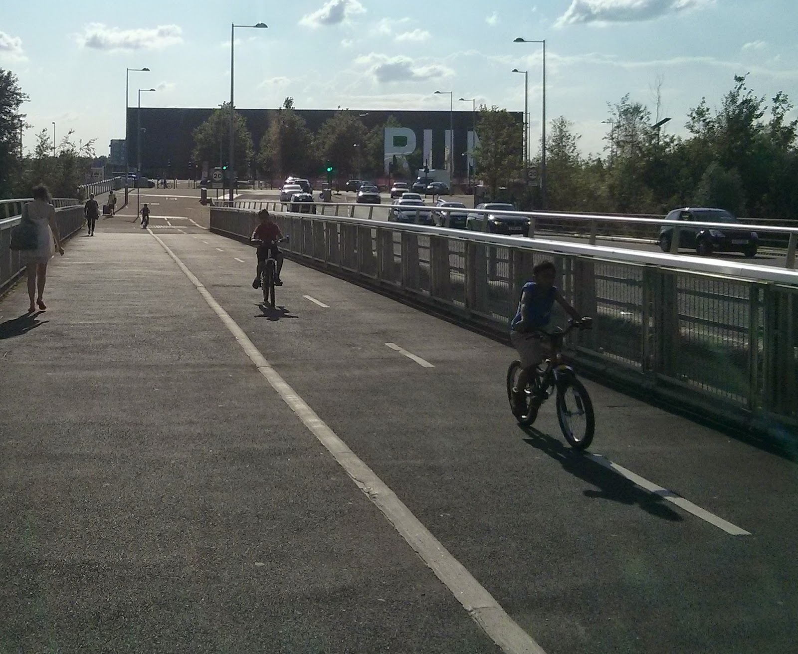
 |
| The children cycling here on Waterden Road are oblivious to the ambulance on an emergency call on the road alongside them |
I was under the impression that LCCs motion 3 was quite clear in its meaning but apparently campaigning to remove cycle tracks and force people into vehicular cycling is in line with this policy. Someone will have to explain this to me as I just don't get it but in the meantime I'll continue to not renew my LCC membership until they no longer adopt a vehicular cycling policy within Hackney.
I've always found it strange that Waterden Road is the only road within the park to get this treatment. Elsewhere roads have cycle tracks that stop before any obstruction, tracks that don't stop for any obstruction, cycle lanes that are so small you can't even use them and others, such as in Sweetwater, offer nothing at all. The original planning application to upgrade Waterden Road back in 2011 granted permission for a dual carriageway to be built:
The original plans here show, just like on Westfield Avenue, cycle tracks on the pavement that give up way before you get to the junction and two-tier cycle provision with ASLs also at the traffic lights to cater for the eight people in Greater London who still want to cycle among heavy traffic.
For some reason this design was changed with another proposal submitted in early 2013 to instead create a single carriageway road. Planning permission was granted but included a number of conditions including regularly carrying out traffic surveys "to analyse traffic conditions on, and in the vicinity of, Waterden Road to demonstrate the performance of the road network. The performance of Waterden Road and the associated network will then determine if the road should be retained as a single lane, two-way route or to be widened to a two-way dual carriageway as per the original planning condition." In the most recent survey they've measured the amount of "vehicles" using the road but this presumably means only counting vehicles that use the road, with people using the cycle track not taken into account.
The survey also shows that traffic travels at an average speed of 30mph along here, despite having a 20mph speed limit.
Queen Elizabeth Olympic Park is a public transport destination they say here on this page explaining to people visiting the Copper Box Arena how to use the over-twice-as-long-as-the-Copper-Box Multi-Storey car park located in the North West of the park, which has space for 554 cars. Meanwhile this page says if you are not using a specific venue then they advise to use the 5,000 capacity car park at Westfield shopping Centre and they also talk of how the car parks are free of charge at the VeloPark and at the Hockey and Tennis centre. They don't even mention the 850 capacity Stratford International multi storey car park which is also located within the Olympic Park. Not forgetting the large amount of on street parking available and the total lack of enforcement when it comes to pavement parking. So it definitely is a public transport destination except for the fact they provide parking for thousand and thousands of cars and if enough of you do drive here then they'll rip up the cycle track and slap a dual carriageway down instead. Still, they've paid a web developer to write the sentence "public transport destination" on their website.
Westfield avenue and its assault course cycle track is now something didn't think could be possible, it is actually even worse to cycle on than it was last year. Firstly these roadworks have been in place for a few weeks
The vast empty space alongside Westfield Avenue where the army searched spectators during the Olympics has recently been both a circus and Hill Valley. This means the track often gets used as a storage area for barriers when the shows are over
and due to the dropped kerb here to allow security to let various vehicles into the central area of the park people like to use the cycle track as a car park or drop off point
Even the Google Streetview car caught a lorry doing this when it drove down Westfield Avenue last summer. Still, within the next year construction is due to start on the International Quarter here where a large number of Skyscrapers will be built, as you can see in this render here on the website of the Financial Conduct Authority, who will be moving 3000 staff here. TFL are also moving thousands of staff here so expect that cycle track to get much busier with parked vehicles.
Meanwhile the cycle track along the southern section of Westfield Avenue has been closed since last summer and will remain closed until 2016
With "Cyclists dismount and use other carriageway" signs in place but no temporary temporary cycle facilities have been built on the other carriageway to assist anyone
The closure of the cycle track is due to what is currently some concrete stubs but will soon be Glasshouse gardens, two towers of 30 and 17 storeys that don't look too different to the council blocks over the road in the Carpenters estate to me. Due to much needed local affordable housing in East London these were launched in Singapore and Hong Kong and Rightmove are already flogging compact one bedroom flats for just over half a mllion pounds
All of these closures and obstructions on the cycle track could have been avoided had the cycle tracks been built to Dutch standards in the first place, which should have been easy enough considering the Olympic Park was a complete blank slate. Astonishing to think that Westfield Avenue was just some mud in a building site exactly five years ago.
A lot has changed within the park over the last two-and-a-half years and there will be many more changes over the next few. Construction of the apartments in Chobham Manor and Glasshouse Gardens is underway with East Wick and Sweetwater due to start soon. The Olympic Stadium will once again welcome spectators during the World Cup later this year before West Ham move in a year later. By then it'll be a major workplace with people moving into offices in Here East and the International Quarter just in time for Crossrail to arrive in about four years time. The park will be a very different place with billions of pounds pumped into it. Let's hope they spend just a small amount of it on repairing the cycle infrastructure and make it a truly great place to cycle rather than the frustrating experience it can be now.
Subscribe to:
Posts (Atom)